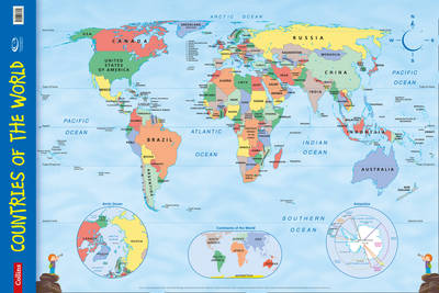
Every primary school needs this brightly coloured map of the world's countries. Uncluttered with unnecessary detail, this is a great visual aid for kids to learn geography and advance their understanding of the world. The map is clearly labelled with country names and oceans making it ideal for teaching the location of places.
Alongside the large political map there are inset maps of the polar regions and the continents.
This wall chart is laminated on one side and supplied rolled and shrink-wrapped. It is ideal for mounting on a classroom wall or for home study.Dimensions 610 X 915 mm.
Makes learning fun.
Published in association with the Geographical Association.
This is Book 11 in the Collins Primary Atlases Series. See all Collins Primary Atlases books here.
No one has written a review for 'Countries of the World: Wall Map'
Why not be the first to share your opinion?
Explore the world through accurate and up-to-date mapping.
More about Collins Maps